![]()
Leo
and I decided to head up to the Santa Cruz Mountains for a quick backpacking
trip. We originally were going to do a snow trip, but the snow this
year just wasn't around long enough for us to get up there and camp
in it. There is always next year. We hadn't been to Castle Rock State
Park in a while so it gave us an excuse to get out and see if anything
had changed. 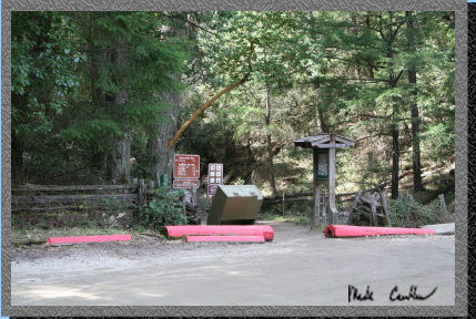 You
do not need reservations to camp at the trail camp. Everything is first
come first serve. When we talked to the ranger she let us know that
last Memorial Day was the first time they were full since 1962. So I
think the rule is don't be crazy enough to try to backpack over a popular
weekend unless you want to be elbow to elbow. Apparently many of the
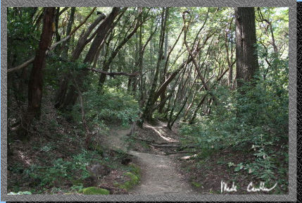
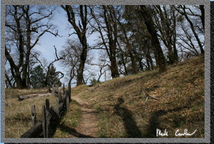
people were Boy Scouts. Here is a picture of the trailhead. To get to
the trailhead heading South on 680 toward San Jose continue until it
turns into 280. Take the Saratoga exit South. This turns into Highway
9. At the junction of Highway 35 take a left and the entrance is on
the right side.
You
do not need reservations to camp at the trail camp. Everything is first
come first serve. When we talked to the ranger she let us know that
last Memorial Day was the first time they were full since 1962. So I
think the rule is don't be crazy enough to try to backpack over a popular
weekend unless you want to be elbow to elbow. Apparently many of the
people were Boy Scouts. Here is a picture of the trailhead. To get to
the trailhead heading South on 680 toward San Jose continue until it
turns into 280. Take the Saratoga exit South. This turns into Highway
9. At the junction of Highway 35 take a left and the entrance is on
the right side.
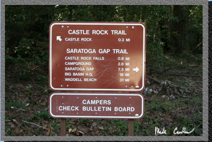 Check
in with the Ranger to see what the latest news is. There are a couple
different options on routes to the trail camp and if you want to hike
a little bit further you can camp at Frog Flat. I recommend #3 as we
have stayed there before and it is nice and usually you can have all
of Frog Flat to yourself. I think it is only 3 or 4 tenths of a mile
past the trail camp sites. We were camping on a Friday night and since
it is so early in the season we expected to have most if not all of
the camp to ourselves. We had one other group come up but they camped
just out of earshot. We took the Saratoga Ridge Trail to the trail camp
(2.7 miles). See
map/profile below.
Check
in with the Ranger to see what the latest news is. There are a couple
different options on routes to the trail camp and if you want to hike
a little bit further you can camp at Frog Flat. I recommend #3 as we
have stayed there before and it is nice and usually you can have all
of Frog Flat to yourself. I think it is only 3 or 4 tenths of a mile
past the trail camp sites. We were camping on a Friday night and since
it is so early in the season we expected to have most if not all of
the camp to ourselves. We had one other group come up but they camped
just out of earshot. We took the Saratoga Ridge Trail to the trail camp
(2.7 miles). See
map/profile below.
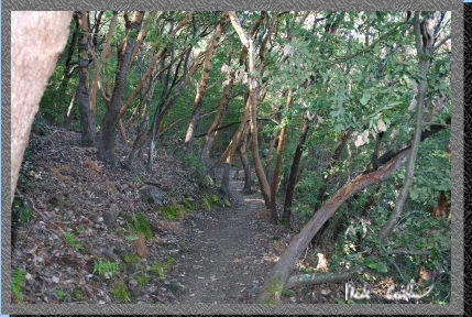
 Most
of the trail is covered as is typical in this area. The trail is easy
and well marked (except for a decent uphill section at Goat Rock). Make
sure to keep an eye out for Poison oak as it is plentiful. There are
some great views on the way as well. i recommend hiking the whole Skyline
to the Sea trail if you can make the time. It can be done in 2 nights
with roughly 10 mile days. The trip is great (Eventually I will get
the pictures on here, still have to scan them).
Most
of the trail is covered as is typical in this area. The trail is easy
and well marked (except for a decent uphill section at Goat Rock). Make
sure to keep an eye out for Poison oak as it is plentiful. There are
some great views on the way as well. i recommend hiking the whole Skyline
to the Sea trail if you can make the time. It can be done in 2 nights
with roughly 10 mile days. The trip is great (Eventually I will get
the pictures on here, still have to scan them).
 The
rock's in the area bring out the climbers so don't be surprised to see
a mess of them (especially on the weekends).
The
rock's in the area bring out the climbers so don't be surprised to see
a mess of them (especially on the weekends).
 Here
is Leo contemplating moving this rock a little further from the trail.
He decided that he would use his leave no trace skills and just leave
the rock, this time.
Here
is Leo contemplating moving this rock a little further from the trail.
He decided that he would use his leave no trace skills and just leave
the rock, this time.
 There
are some of the great views on the way to Goat Rock. It was a little
hazy as there were a few burns going on in the distance.
There
are some of the great views on the way to Goat Rock. It was a little
hazy as there were a few burns going on in the distance.
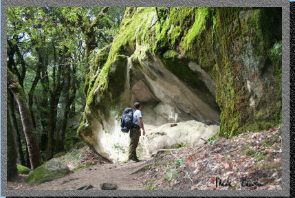
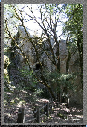
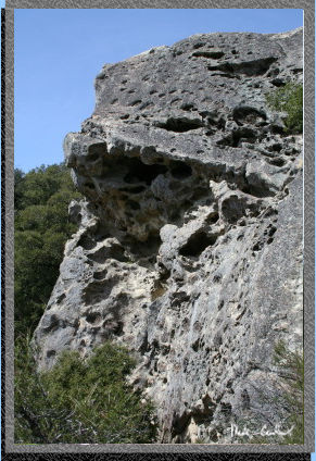 Here
is Goat Rock. You can see why the climbers are all over this place.
There are a few spots on the trail that go out to the base of these
rocks so unless that is your plan, stay on the more traveled path. There
are some steep sections along the trail so you should be careful as
you hike as a slip could put you well off the trail.
Here
is Goat Rock. You can see why the climbers are all over this place.
There are a few spots on the trail that go out to the base of these
rocks so unless that is your plan, stay on the more traveled path. There
are some steep sections along the trail so you should be careful as
you hike as a slip could put you well off the trail.
 Here
is the section of trail after Goat Rock. There is an interpretive center
option here if you go right instead of straight at the junction at the
top of Goat Rock. You can actually climb up to the top of goat rock.
It is a nice view.
Here
is the section of trail after Goat Rock. There is an interpretive center
option here if you go right instead of straight at the junction at the
top of Goat Rock. You can actually climb up to the top of goat rock.
It is a nice view.
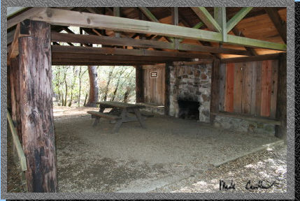 Here
is the shelter at the trail camp. Leo and I did hang out in this shelter
one year when it poured on us. It was a great test of our tents waterproofness.
Is that a word? There are signs posted that you should only camp in
the shelter in inclement weather. Remember that you are in the Santa
Cruz Mountains, so if it does start raining expect to have a good test
of your rain gear (you did bring it, right?).
Here
is the shelter at the trail camp. Leo and I did hang out in this shelter
one year when it poured on us. It was a great test of our tents waterproofness.
Is that a word? There are signs posted that you should only camp in
the shelter in inclement weather. Remember that you are in the Santa
Cruz Mountains, so if it does start raining expect to have a good test
of your rain gear (you did bring it, right?).
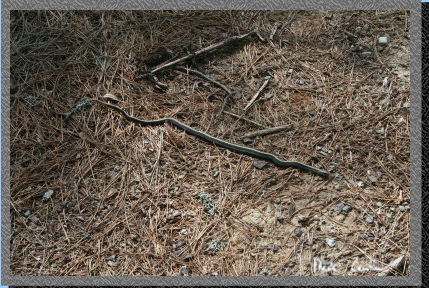 Here
is a little snake friend we saw while hiking around the sites looking
for one that we remembered from another trip.
Here
is a little snake friend we saw while hiking around the sites looking
for one that we remembered from another trip.
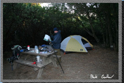 Here
is our site, #18. There are tables at the sites, running water from
faucets nearby and a few pit toilets. I know, not exactly roughing it
but it is nice to get out here and recharge.
Here
is our site, #18. There are tables at the sites, running water from
faucets nearby and a few pit toilets. I know, not exactly roughing it
but it is nice to get out here and recharge.
 It
was a little windy that night but there were no mosquitoes and we both
had enough gear to stay warm. We stayed up playing cards and chatting.
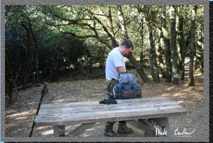
Here is Leo packing up in the morning. You are allowed to burn fires
here as long as the fire danger is low. They even provide wood bundles
for $7. Make sure to bring some cash if that is something you want to
do.
It
was a little windy that night but there were no mosquitoes and we both
had enough gear to stay warm. We stayed up playing cards and chatting.
Here is Leo packing up in the morning. You are allowed to burn fires
here as long as the fire danger is low. They even provide wood bundles
for $7. Make sure to bring some cash if that is something you want to
do.
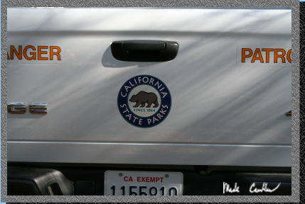
We saw the ranger on the way out. She was checking to make sure everyone at the trail camp was registered (us and one other group) and generally checking on things. She was driving the nicest Ranger truck I have seen.
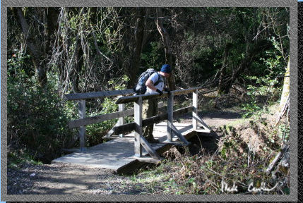 Here
is Leo as we hiked over the creek near the trail camp on the way back.
It was still cool when we started out but it warmed up as we got closer
to the car.
Here
is Leo as we hiked over the creek near the trail camp on the way back.
It was still cool when we started out but it warmed up as we got closer
to the car.
 It
is amazing how much the foliage changes on this trail.
It
is amazing how much the foliage changes on this trail.
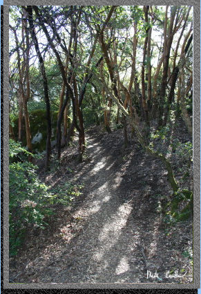 Here
is the sun breaking though some of the cover. The temperature can vary
a great deal depending on the wind and the section of the trail you
are on.
Here
is the sun breaking though some of the cover. The temperature can vary
a great deal depending on the wind and the section of the trail you
are on.
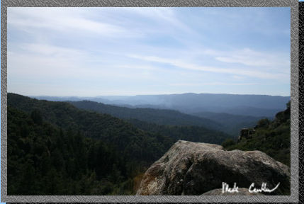
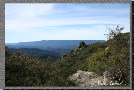 Here
is another view of the surrounding valley.
Here
is another view of the surrounding valley.
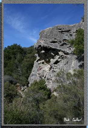 Here
is Goat rock with a couple people climbing it. We left on a Saturday
morning and saw quite a few climbers on the way in. I am not sure what
the rules are amongst climbers as far as sharing the "Rocks".
I assume there is some nice way to share the time or routes on the rocks
in the area. If you want them to yourself try going during the week.
I saw only one group of climbers on Friday and I imagine that in the
middle of the week there are even less.
Here
is Goat rock with a couple people climbing it. We left on a Saturday
morning and saw quite a few climbers on the way in. I am not sure what
the rules are amongst climbers as far as sharing the "Rocks".
I assume there is some nice way to share the time or routes on the rocks
in the area. If you want them to yourself try going during the week.
I saw only one group of climbers on Friday and I imagine that in the
middle of the week there are even less.
 I
do not remember the name of this rock but I liked the lines in the picture.
I
do not remember the name of this rock but I liked the lines in the picture.
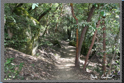
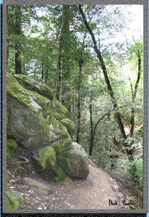
More Shots of the trail pretty close to the trailhead. Notice the moss covered rocks. It is much cooler through these well covered sections along the stream.
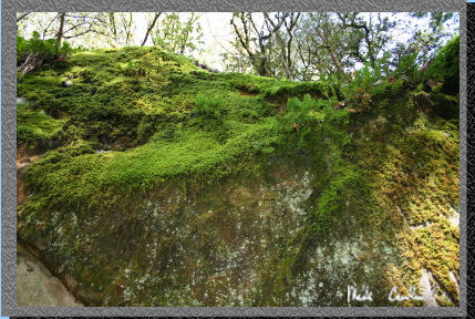 In
case you missed the rock.
In
case you missed the rock.
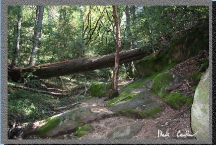
Here is the last section on the way back. This tree that fell over the trail is huge and I am not sure if they will try to remove it or not. I am sure that this tree came down with more than a thud. This is a great trip and I would recommend it to anyone looking to do a nice warm up trip to try out new gear. Make sure to pack rain gear and a tent that is sealed well from rain.
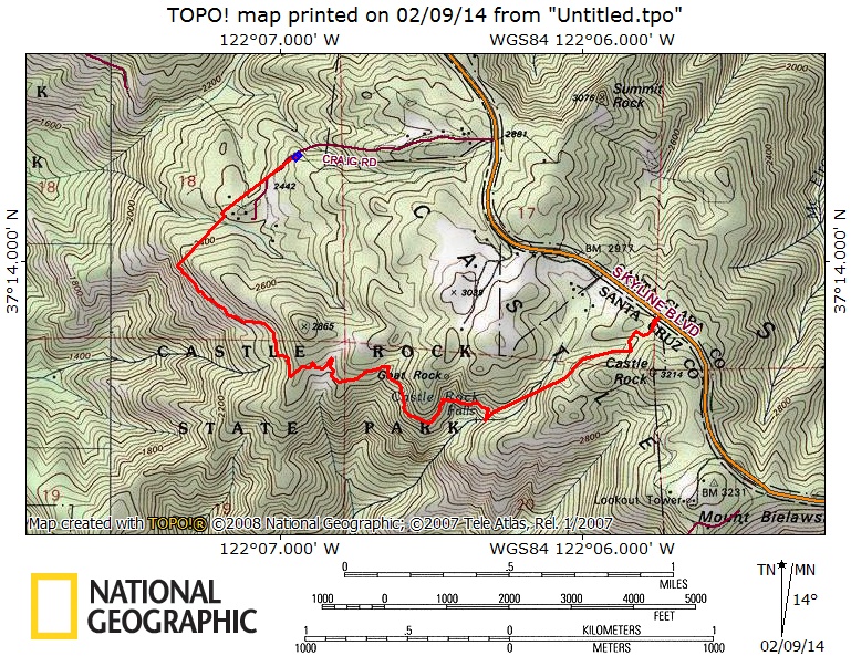
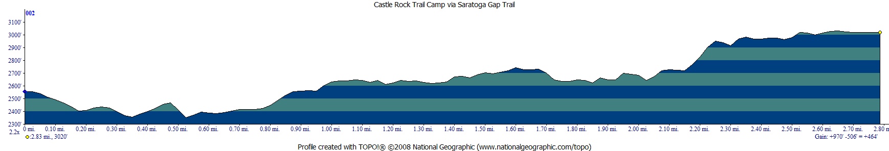
Map and profile from Trailhead to Castle Rock Trail Camp is shown below (gps track is from a 2014 trip in the rain). The shelter is great when it starts to pour Santa Cruz style on you. Click on either one for a larger version..