![]()
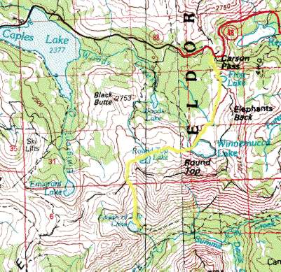
This backpacking trip was done in the Mokelumne Wilderness (South of Lake Tahoe). This is a great hike if you want to see some of the gorgeous high country and have it to yourself (only when you are hiking it at this time of year though). The trail takes you past 4 alpine lakes and allows some great views of Caples Lake. The trail is about 5 miles each way and starts out around 8500 ft and has a high point of 9400 ft. map
To
get to the trailhead take 88 to the Carson 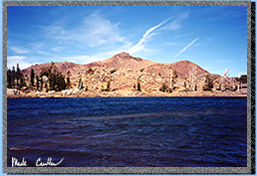 Pass
Summit. Park at the parking lot on the South side of highway 88 and
the trailhead is at the western end of the parking area. In the summer
you can obtain your wilderness permit from the cabin like structure
here but other times of the year hit a ranger station on the way (or
plan ahead and have it mailed to you). This picture was taken of Frog
Lake on the way out. It was a little that day as you can see by the
waves on the lake. After passing Frog Lake you come to a signed junction
where I went right. You can make this a loop trail if you decide to
extend this trip. You can get to Fourth of July Lake by going either
way here but going right is shorter and easier. I have done the whole
loop and my only bit of advice is to make sure that there is no snow
or be prepared to cross some major steep snowfields.
Pass
Summit. Park at the parking lot on the South side of highway 88 and
the trailhead is at the western end of the parking area. In the summer
you can obtain your wilderness permit from the cabin like structure
here but other times of the year hit a ranger station on the way (or
plan ahead and have it mailed to you). This picture was taken of Frog
Lake on the way out. It was a little that day as you can see by the
waves on the lake. After passing Frog Lake you come to a signed junction
where I went right. You can make this a loop trail if you decide to
extend this trip. You can get to Fourth of July Lake by going either
way here but going right is shorter and easier. I have done the whole
loop and my only bit of advice is to make sure that there is no snow
or be prepared to cross some major steep snowfields.
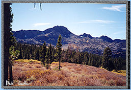
 There
are some great views to be had on this trip. Both Winnemucca Lake and
Round Top Lake are surrounded by sheer cliffs. The clear water of the
lakes reflecting the dark peaks makes for quite a sight.
There
are some great views to be had on this trip. Both Winnemucca Lake and
Round Top Lake are surrounded by sheer cliffs. The clear water of the
lakes reflecting the dark peaks makes for quite a sight.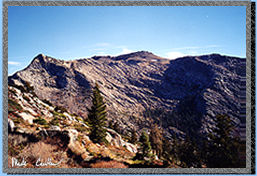 There
are a few campsites around these lakes but check when you get your permit
to see if you can stay at them. This area was overused and there are
restrictions now on which lake you can camp by.
There
are a few campsites around these lakes but check when you get your permit
to see if you can stay at them. This area was overused and there are
restrictions now on which lake you can camp by.
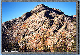
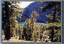
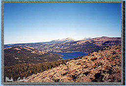 Views
like this make you realize how high up you are. The high point on this
trip is Round Top Lake (9400 ft) but on the way you get views like this
of Caples Lake. The trail here is cut out of a particularly steep section
of trail. I did this hike one time early in the season and crossing
snow here is quite treacherous.
Views
like this make you realize how high up you are. The high point on this
trip is Round Top Lake (9400 ft) but on the way you get views like this
of Caples Lake. The trail here is cut out of a particularly steep section
of trail. I did this hike one time early in the season and crossing
snow here is quite treacherous. 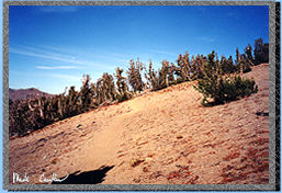
 Unfortunately
I am writing this description a few months after I hiked it. I am not
sure if this is Winnemucca Lake but I am pretty sure it is. There is
a trail junction at both lakes. Just stay to the left. I haven't taken
either of these trails. One goes to Woods Lake and the other to Lost
Cabin Mine. Next time I do this trail I will have to check them out.
Unfortunately
I am writing this description a few months after I hiked it. I am not
sure if this is Winnemucca Lake but I am pretty sure it is. There is
a trail junction at both lakes. Just stay to the left. I haven't taken
either of these trails. One goes to Woods Lake and the other to Lost
Cabin Mine. Next time I do this trail I will have to check them out.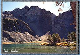
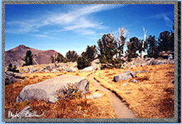
 The
trail is pretty much downhill after you reach Round Top Lake. You pass
an old Wilderness Boundary sign on the way. The trail is steep but it
is switch-backed which helps a bunch. They have started to number the
site now at this lake so you get to pick a number when you get your
permit. I picked #6. It was pretty open but it did offer some great
stargazing in the cool fall night. If it would have been windy that
night I might have had a different outlook on this site.
The
trail is pretty much downhill after you reach Round Top Lake. You pass
an old Wilderness Boundary sign on the way. The trail is steep but it
is switch-backed which helps a bunch. They have started to number the
site now at this lake so you get to pick a number when you get your
permit. I picked #6. It was pretty open but it did offer some great
stargazing in the cool fall night. If it would have been windy that
night I might have had a different outlook on this site.
The next day out was as glorious as the first. A slight breeze and cool but that is the best weather for backpacking in my opinion.
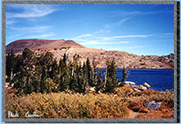 This
is a picture of Winnemucca Lake on the way out. I forgot to mention
that I bumped into some hikers on the way out of Fourth of July Lake
on the way in and they report good fishing at Fourth of July Lake. If
you still have to pick a number when you do this hike then pick number
5. I camped there a few years ago (it was not labeled then) and that
seemed to be the best spot. My GPS unit reported that this hike is actually
5.24 miles and it took me about 2 hours to get there and about 2 1/2
hours to get out. I think I was in a little more of a hurry to get there
then to get back to the car. A great place to go but very popular on
summer weekends.
This
is a picture of Winnemucca Lake on the way out. I forgot to mention
that I bumped into some hikers on the way out of Fourth of July Lake
on the way in and they report good fishing at Fourth of July Lake. If
you still have to pick a number when you do this hike then pick number
5. I camped there a few years ago (it was not labeled then) and that
seemed to be the best spot. My GPS unit reported that this hike is actually
5.24 miles and it took me about 2 hours to get there and about 2 1/2
hours to get out. I think I was in a little more of a hurry to get there
then to get back to the car. A great place to go but very popular on
summer weekends.