


![]()
Penner
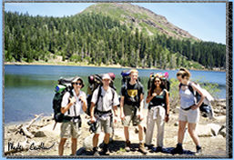
lake is located in the Tahoe National Forest. My companions on this
trip include: Dan, Margaret, Mike and Deepa. We got a late start on
Saturday morning; we didn't leave until 10 am from Davis. The drive
to Carr Lake trailhead is not too bad. If you are traveling north on
80 take the highway 20 exit and travel west. After traveling for about
4 miles take a right turn on Bowman road, not Lake Spalding Road like
we did accidentally. Drive on until you see a sign for Carr Lake at
about 8.5 miles and take a right. This road is a little rough but both
of our cars made it through the approximately 2 � miles fine.  Dan's
car is an Escort so you can have some idea what car can make it. It
does get a little rough in spots, and the whole way is gravel so driving
slow is a must. Watch out for people in big trucks going too fast on
this narrow road. Once you make it to the trailhead you will see how
popular this trail is. Most of the folks using this area are day hikers
or stay at some of the closer lakes to the trailhead. This was not really
the case this holiday weekend though. Parking at the trailhead isn't
great but once the lot at the top of the hill is filled people start
parking on the road on the left hand side. There is also a small open
section on the right hand side as you ascend up the hill to the trailhead.
After finding a good parking spot we headed up the hill and reached
the trailhead.
Dan's
car is an Escort so you can have some idea what car can make it. It
does get a little rough in spots, and the whole way is gravel so driving
slow is a must. Watch out for people in big trucks going too fast on
this narrow road. Once you make it to the trailhead you will see how
popular this trail is. Most of the folks using this area are day hikers
or stay at some of the closer lakes to the trailhead. This was not really
the case this holiday weekend though. Parking at the trailhead isn't
great but once the lot at the top of the hill is filled people start
parking on the road on the left hand side. There is also a small open
section on the right hand side as you ascend up the hill to the trailhead.
After finding a good parking spot we headed up the hill and reached
the trailhead.
 The
hike to Penner Lake is about 3 miles (see map below).
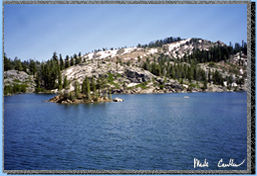
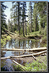
A few steps past the trailhead we were greeted with a view of Carr Lake.
(A beautiful little lake even with the hoards of people camping around
it.) We continued on Round Lake Trail as it crossed the outlet of Feely
Lake. The trail continues along the shore of Feely Lake with Fall Creek
Mountain looming above
it (See picture on left).
The
hike to Penner Lake is about 3 miles (see map below).
A few steps past the trailhead we were greeted with a view of Carr Lake.
(A beautiful little lake even with the hoards of people camping around
it.) We continued on Round Lake Trail as it crossed the outlet of Feely
Lake. The trail continues along the shore of Feely Lake with Fall Creek
Mountain looming above
it (See picture on left).
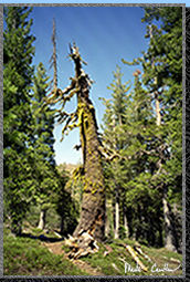
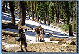 The
trail climbs a bit to the first trail junction and we had to cross some
snow amongst the shade of the pines (see picture on right). At the first
trail junction take a left (about 1 mile form the trailhead) onto Crooked
Lakes Trail.
The
trail climbs a bit to the first trail junction and we had to cross some
snow amongst the shade of the pines (see picture on right). At the first
trail junction take a left (about 1 mile form the trailhead) onto Crooked
Lakes Trail.
 We
passed Island Lake on the right (another gorgeous lake). After hiking
a bit more we stopped for lunch at a shady section near the river at
about 1.7 miles from the trailhead. It was nice to be able to enjoy
a relaxing lunch as we listened to the wind through the trees and the
rushing water. There were still patches of snow in the shady sections.
Just enough snow to grab a handful and throw at your friends.
We
passed Island Lake on the right (another gorgeous lake). After hiking
a bit more we stopped for lunch at a shady section near the river at
about 1.7 miles from the trailhead. It was nice to be able to enjoy
a relaxing lunch as we listened to the wind through the trees and the
rushing water. There were still patches of snow in the shady sections.
Just enough snow to grab a handful and throw at your friends.
 Continuing
on the the trail we passed by the Crooked Lakes. There are quite a few
of these lakes to choose from if you are interested in camping more
by yourself. We didn't make the trek around any of the Island Lakes
so I am not sure what kind of camping spots lie around these lakes.
(On the hike out there were some people camped at the edge of a few
of them.)
Continuing
on the the trail we passed by the Crooked Lakes. There are quite a few
of these lakes to choose from if you are interested in camping more
by yourself. We didn't make the trek around any of the Island Lakes
so I am not sure what kind of camping spots lie around these lakes.
(On the hike out there were some people camped at the edge of a few
of them.)
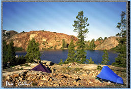 The
last section before Penner Lake is pretty steep but you get some nice
views of The Black Buttes along the way. Once reaching Lake Penner we
got to tackle the problem of finding a campsite in which we could pitch
3 tents reasonably close together. After quite a bit of scouting of
both side of the lake we decided on a site on the northeast side of
the lake. You can see my trusty blue Sierra Design Light Year and Dan's
purple tent (I forget the make, but Margaret thinks it is exceptionally
water tight :-)
The
last section before Penner Lake is pretty steep but you get some nice
views of The Black Buttes along the way. Once reaching Lake Penner we
got to tackle the problem of finding a campsite in which we could pitch
3 tents reasonably close together. After quite a bit of scouting of
both side of the lake we decided on a site on the northeast side of
the lake. You can see my trusty blue Sierra Design Light Year and Dan's
purple tent (I forget the make, but Margaret thinks it is exceptionally
water tight :-)
After setting up camp Dan went fishing and I decided to go for a swim. The water was cold but the sun was shining and if it wasn't for the wind it wasn't to bad of a day for a swim at 6900 feet. It is amazing how fast that cold water can take your breath away. I guess that is half of the thrill. Well I didn't stay in for very long, but long enough to be a little numb when I got out. After drying off I changed into some warm clothes. It was dinner time before we knew it. Cheese Tortellini and fresh fish were the specials tonight. Some people in our group wanted a fire. I was outvoted and we had one. Fires aren't something I enjoy much anymore. I guess I have seen too many of the negative effects from them to justify them. We made an early night of it because the wind was really picking up.
Dan, Margaret and I headed out about nine the next morning (Deepa and Mike had decided to stay one more night). The trip out was pleasantly uneventful. I am going to end this trip description with a few pictures from the way out. I would recommend this trip to anyone that is into backpacking.This trip offers some great views with modest mileage. If you want to try something a little more challenging I recommend taking the Sand Ridge trail to Five Lakes Basin (It offers some ridge walking and a better chance at solitude with even more great vistas).
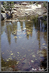
The picture in the center is actually of a fire pit that was completely submerged by snow melt.
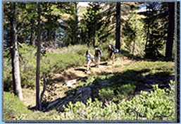
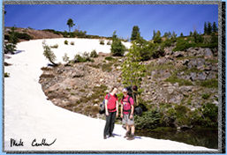 This
picture is of Dan and Margaret not far from Lake Penner on our trek
back to the car.
This
picture is of Dan and Margaret not far from Lake Penner on our trek
back to the car.
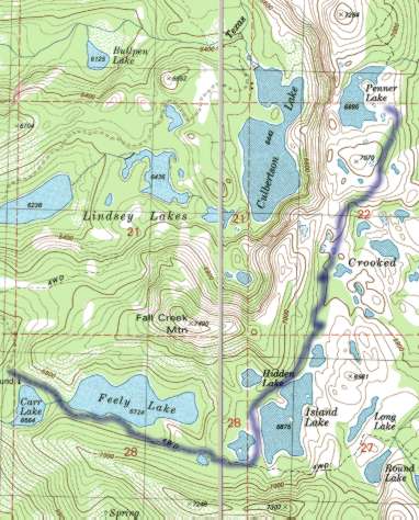
On the map above you can see the start of the trail very close to Carr Lake. (You actually used to be able to drive to Feely lake before parking.) The trail we took is only shown on this map until Island Lake so I made an attempt to draw our route to Penner Lake with the fuzzy purple line. Don't count on seeing the fuzzy line when you are on the trail.