![]()
This
is a great backpacking trip in one of the less used areas of the Mokelumne Wilderness (South of Lake Tahoe). The trailhead I decided
to use is located near Plasse's Resort off highway 88. If you are heading
East on highway 88 take a right on Plasse Road (on the downhill section
before you reach Silver Lake). Follow the signs to Stockton Silver Lake
Camp (you will pass by
of the Mokelumne Wilderness (South of Lake Tahoe). The trailhead I decided
to use is located near Plasse's Resort off highway 88. If you are heading
East on highway 88 take a right on Plasse Road (on the downhill section
before you reach Silver Lake). Follow the signs to Stockton Silver Lake
Camp (you will pass by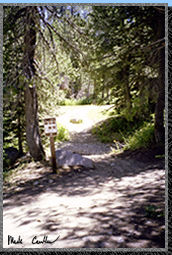 Plasse's Resort). As you near the Stockton Silver Lake Camp parking
lot there is an orange gate with a place to park two cars on the East
side of the road (right before the gate). The trailhead is about 100
feet South (back towards the way you came in) on the East side of the
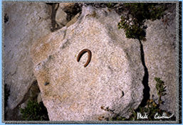
road. map There is a rather small sign marking the
trailhead (see picture on left) but there are larger signs after you
cross the creek. I parked at N 38 38'01.8" W 120 07'36.6".
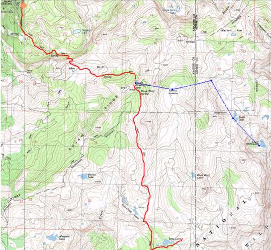
Basically the orange ellipse on the map.
Plasse's Resort). As you near the Stockton Silver Lake Camp parking
lot there is an orange gate with a place to park two cars on the East
side of the road (right before the gate). The trailhead is about 100
feet South (back towards the way you came in) on the East side of the
road. map There is a rather small sign marking the
trailhead (see picture on left) but there are larger signs after you
cross the creek. I parked at N 38 38'01.8" W 120 07'36.6".
Basically the orange ellipse on the map.
I was
going it alone on this 7 mile journey. The trail is very dusty but 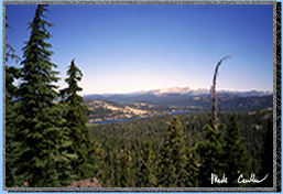 easy
to follow. On the map the red line is the course
I took on this trip (the blue line is where I took my next trip, Lake
Beebe). The trail starts in a generally South direction and also
generally uphill. This section of trail is open to dirt bikes and horses
so keep an eye and an ear out for both. At the first signed trail junction
you can hang a left to go to Hidden Lake. Continue on to get to Long
Lake. The trail gets steep and windy in the next section (luckily it
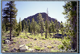
is shaded) until you make it to the top of the ridge. I took the picture
on the right from that ridge. You get a great view of Silver Lake.
easy
to follow. On the map the red line is the course
I took on this trip (the blue line is where I took my next trip, Lake
Beebe). The trail starts in a generally South direction and also
generally uphill. This section of trail is open to dirt bikes and horses
so keep an eye and an ear out for both. At the first signed trail junction
you can hang a left to go to Hidden Lake. Continue on to get to Long
Lake. The trail gets steep and windy in the next section (luckily it
is shaded) until you make it to the top of the ridge. I took the picture
on the right from that ridge. You get a great view of Silver Lake.
After
passing through the barbed wire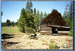 gate continue down off the ridge and onto the dirt road. Make a left,
watching for traffic. You soon come up on Allen Ranch. You will probably
hear the cows before you see the ranch. Although it doesn't look like
an active ranch it is. There is a new ranch house behind this one and
I saw activity around it.
gate continue down off the ridge and onto the dirt road. Make a left,
watching for traffic. You soon come up on Allen Ranch. You will probably
hear the cows before you see the ranch. Although it doesn't look like
an active ranch it is. There is a new ranch house behind this one and
I saw activity around it.
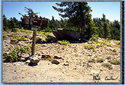
The
trail continues back up now you come to a couple spur trails but stick
to the road to the top of Squaw Ridge. I took the picture on the right
on the top of the ridge. The trail continues in both directions here
on top of the ridge. This ridge also marks the boundary for The Mokelumne
Wilderness. Make a right and pass by a historic marker for Plasse's
 Trading
Post (a stop for the Mormons on the Mormon Carson Pass Emigrant Trail).
Continue down the road until you see the Mokelumne Wilderness boundary
in the left. You can breath a sigh of relief now that you are out of
the path of the 4-wheelers. There are some great wild flower filled
meadows that you pass through in this section. Unfortunately
Trading
Post (a stop for the Mormons on the Mormon Carson Pass Emigrant Trail).
Continue down the road until you see the Mokelumne Wilderness boundary
in the left. You can breath a sigh of relief now that you are out of
the path of the 4-wheelers. There are some great wild flower filled
meadows that you pass through in this section. Unfortunately 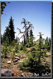 you
also pass by a rock that someone decided it would be fun to write the
words "help" on it. Continuing on the trail you pass through the old
wilderness boundary marked with some partially excavated concrete posts.
Don't forget to look up in the next section to see some wonderful trees
(even after death they stand against the elements). Enjoy the great
views of the neighboring peaks in the next section.
you
also pass by a rock that someone decided it would be fun to write the
words "help" on it. Continuing on the trail you pass through the old
wilderness boundary marked with some partially excavated concrete posts.
Don't forget to look up in the next section to see some wonderful trees
(even after death they stand against the elements). Enjoy the great
views of the neighboring peaks in the next section.
After
a steep downhill section you come to a trail junction.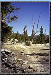 Take a left for Black Rock Lake or go straight for Long Lake. After
a short uphill section go downhill to a flat granite field well marked
with rocks, blazes and ducks (see picture on right). You come to another
junction after a downhill section. Continue on the trail towards Long
Lake or go right for Cole Creek Lakes. (The trail to Long Lake actually
goes by the last of the Cole Creek Lakes.) map. This
last section of trail is a little harder to follow so keep an eye on
the trail. I think too many people have been unsure on which is the
main trail here so some of the spur trails look quite convincing.
Take a left for Black Rock Lake or go straight for Long Lake. After
a short uphill section go downhill to a flat granite field well marked
with rocks, blazes and ducks (see picture on right). You come to another
junction after a downhill section. Continue on the trail towards Long
Lake or go right for Cole Creek Lakes. (The trail to Long Lake actually
goes by the last of the Cole Creek Lakes.) map. This
last section of trail is a little harder to follow so keep an eye on
the trail. I think too many people have been unsure on which is the
main trail here so some of the spur trails look quite convincing.
Eventually
you will come to another trail marker for Munson Meadow. 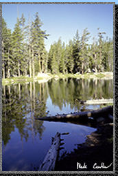 Turn
left here and immediately cross two big fallen trees. Follow the trail
to Long Lake. I was lucky enough to have Long Lake to myself this Saturday
night. Long Lake is not the deepest of lakes but it does offer swimming
possibilities and some moderate size fish to be caught. I saw plenty
jumping that evening. It took me close to 4 hours to hike in and almost
3 1/2 hours on the way out. I took my time for the most part, taking
pictures, writing in my journal, and talking with people on the trail.
My camp was at N 38 34' 28.5" W 120 04' 48.7". Not quite at
the end of the red line on the map.
Turn
left here and immediately cross two big fallen trees. Follow the trail
to Long Lake. I was lucky enough to have Long Lake to myself this Saturday
night. Long Lake is not the deepest of lakes but it does offer swimming
possibilities and some moderate size fish to be caught. I saw plenty
jumping that evening. It took me close to 4 hours to hike in and almost
3 1/2 hours on the way out. I took my time for the most part, taking
pictures, writing in my journal, and talking with people on the trail.
My camp was at N 38 34' 28.5" W 120 04' 48.7". Not quite at
the end of the red line on the map.
There
are plenty of things to see in this section of the Mokelumne Wilderness.
 I
bumped into two guys on the way out that had been backpacking in this
area for 9 days. I would recommend this trip to anyone wanting a good
moderate one nighter. But if you can stay longer you could do some sweet
day hikes to some of the neighboring lakes or even move camp a few times.
I will leave you with a couple more shots.
I
bumped into two guys on the way out that had been backpacking in this
area for 9 days. I would recommend this trip to anyone wanting a good
moderate one nighter. But if you can stay longer you could do some sweet
day hikes to some of the neighboring lakes or even move camp a few times.
I will leave you with a couple more shots.