


![]()
 Permit
- A permit is required for all overnight stays in Emigrant Wilderness.
Permits can be obtained in person at the Summit Ranger Station at 1
Pinecrest Road in Pinecrest off Highway 108. There are currently no
trailhead quotas or fees for the permit.
Permit
- A permit is required for all overnight stays in Emigrant Wilderness.
Permits can be obtained in person at the Summit Ranger Station at 1
Pinecrest Road in Pinecrest off Highway 108. There are currently no
trailhead quotas or fees for the permit.
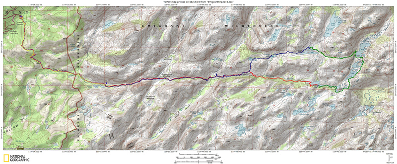
Mileage - We did about 31 miles in total over 4 nights/5 days from Crabtree Trailhead to Grouse Lake, Wood Lake, Deer Lake, Grouse Lake and back to trailhead (also walked by Jewelry Lake, Gem Lake & Buck Lakes). Your mileage may vary depending on site selection. See map/profile below.
Camps/Water/Trailhead - There is a bathroom at Crabtree Trailhead (no water or trash service). You drive through Aspen Meadow Pack Station on the way in (5 MPH speed limit).
Hazards - Black Bears, creek crossings, mice/squirrels, and Mosquitoes. Nearest Ranger # 209-965-3434 (always check with ranger ahead of time for current water/trail conditions).
- Day 1 - Day 2 - Day 3 - Day 4 - Day 5 - (click the day you want or just scroll through them all :-)
Day 3 (Wood Lake to Deer Lake, ~ 5.5 miles) -Green Line-


Tyler and I started
getting ready a little sooner this day. We hit the trail about 9:30
following along the rest of Wood Lake. We had looked at the map and
saw that the trail ahead was drawn over the lake... I even looked at
my old map and it showed the same thing. Bridge? We were both very curious
as to how we were supposed to have a lake crossing.
Here is Wood Lake before we left camp. It really is almost two lakes
connected by a long skinny lake.
Here is the trail
along the lake headed east along the south shore of Wood Lake. The white
stuff is all snow. With the shade on this side of the lake you were
crossing, or next to, a lot of the stuff.

Here is the lake
crossing. You can just make out the trail on the far side of the lake.
I imagine that in drier times this is passable without a swim suit.
Today it was likely at least waist deep. We decided we would just walk
around the end of Wood Lake, rather than find out exactly how deep the
lake crossing was with packs above our heads.

We walked around the lake on a day use trail and saw another campsite
out here, tucked away on this side of the lake. In the shot below you
can see the lake crossing spot where the two areas of green grass narrow
the lake. It almost looks like you can walk across from this angle.

We continued along
Wood Lake and eventually up and over some granite to catch back up with
the official trail again. There is plenty of shade and the trail remains
level through this section. Just after you lose sight of the lake you
will come to the next trail junction. On the right the trail now heads
to Cow Meadow Lake. We took a left toward Lower Buck Lake with a plan
to follow the trail between Lower and Upper Buck Lake.
Here is the trail junction below looking back the way we came from.

Continue along the shores of beautiful Lower Buck Lake and enjoy the
views of some of the 10,000' peaks in the distance. Upper Buck Lake
is listed at 8,300' so there is still plenty of trail left if you want
to explore further to the east. We were almost as far east as we were
traveling on this trip. One day I hope to make it to Emigrant Lake,
maybe in a year when the snow is already melted.

Another shot of
the trail along this portion (see, not all lake views). The grade is
a nice break from the up and down of the previous two days. We encountered
a plethora (yes, I would say a plethora) of dragonflies through this
section. We are convinced that the dragonflies either don't get along
with the mosquitoes, or the mosquitoes are inside the dragonflies, as
there were not many mosquitoes around the dragonflies. We were of course
big fans of the dragonflies on this trip.

Here is the crossing
of the outlet of Upper Buck Lake. We were able to jump across the fast
moving section shown below with the help of a trekking pole.

The trail continues
along the shore of Upper Buck Lake now on the west side. There are some
great views of the surrounding peaks. If you were headed to Emigrant
Lake you would continue along the west side of the lake in a northerly
direction, until eventually turning east to climb up to Emigrant Lake,
which is roughly 500 feet higher than Upper Buck Lake.
Here is the junction
with the trail to Emigrant Lake. We took a left here and started the
climb up to Deer Lake.

The trail continues
up for a while and then heads downhill to the junction with Wood Lake.
Yes, there is another junction with Wood Lake. This would have been
a shortcut, but I would recommend the trail around Buck Lakes as the
views are spectacular, and the trail that you would cutout is pretty
flat. This section of trail has a mixture of covered sections and open
sections. Here is a shot of this section of trail with the uphill.

Here is the junction
with Wood Lake on the left, continue straight on to Deer Lake.

We continued along
the mainly downhill trail now to Deer Lake and made it to a nice campsite
on the north side of the lake, about the middle of the lake. This was
a " busy" lake with other people using it for swimming and
plenty of horses going by. We saw one really nice campsite near ours,
but it was almost on the water (illegal). We walked ours off to be sure
that we were 100' from the water. We were about 125'. We were extra
pleased with our site selection as the mosquitoes weren't around. There
was a slight breeze that was keeping them mainly grounded. Here is a
shot of the lake with the rocky island in the middle (so the lake is
bigger than you can see here). We dropped our packs and brought lunch
and a water filter out to the edge of the lake.

Another shot of
the lake and island looking eastward now. That strange looking fish
is swimming toward me after visiting the patch of snow on the island.

Here is the campsite.
It was on the smaller side but big enough to have the tent and hang
our packs to keep the giant mountain ants out of them.

We had a little fire that night and enjoyed the bug free time. The wind
stopped at some point and the mosquitoes descended into camp. We retreated
into the tent once we had our fill of them. You can see in the shot
below that the wind was coming across the lake. We saw a couple people
fly fishing out on the green area between the sections of lake.

Day 4 (Deer Lake to Grouse Lake, ~ 7.75 miles) -Blue Line-


We headed out on
day four through the flooded section of trail then across the inlet
to Deer Lake. We were getting pretty confident crossing water now. Here
is Tyler crossing the inlet.

The next junction
is with Salt Lick Meadow (also the trail to Wire Lakes). Take a left
here and continue along the shore of Deer Lake.

This is a shot taken
as you pass by the last of Deer Lake. The lake was much more still this
morning than the previous afternoon.

No filters on this picture, just a great pond reflection. 
Some of the granite
out here makes you feel like you discovered another Yosemite Valley.
I think they could have named this section of Emigrant Wilderness "Yosemite
North".

The trail levels
off at the inlet to Jewelry Lake. The inlet is a long, moderately deep,
meandering stream that would be fun to float down as it looks to have
almost no current. I have seen fish in this stream in a previous trip
out here. You will quickly find yourself on the shore of Jewelry Lake.
Another great looking lake surrounded by granite. We didn't see anyone
camping around this lake.

The trail continues
down again over exposed granite sections with more Yosemite like views.
I know I say it a lot but make sure you are looking around while you
hike.

More great views.
The pictures don't do them justice.

Here is the next
trail junction with Piute Lake on the right. Take a left here to see
the east side of Gem Lake. The other option is to continue along the
north side of the lake and stay along the higher trail to Piute Lake
then continue almost to Piute Meadow and make a left to Groundhog Meadow
down the the lower Pine Valley Trail.

Here is the shore
of Gem Lake. There was at least one group camped on the south side of
the lake. They were swimming and their dog wanted to "rescue"
them, but not get wet. He ran up to us and then kept looking at his
owners like we should help him out. Dogs are silly.

We continued our
downward journey now over the exposed granite toward the trail that
runs parallel to Buck Meadow Creek. This would be the last of the "new"
trail we explored on this trip as everything else would be heading back
on trails from either day one or two.

When you get down
to the trail junction take a right and continue downhill following Buck
Meadow Creek. As you can see in this shot it was still flowing nicely.
I took a little video, to see it use this
link.

I tried to take
a picture of every type of flower along the trails edge. Here are a
couple along this section.

These had a cool
pattern. I wished I had taken botany in college to know more of the
names.

Random boulder pic.

It was around here
that we decided we were making really good time and could take a detour
off the official trail over to cascading Cherry Creek to the west.

We took our trek
off trail now and headed to a Cherry Creek pool. We cooled off and had
a snack by the rushing water through here. The water was pretty cold
(as you can imagine) but I still stuck my head in the pool behind Tyler.
I took another video here to capture the sound of the water, use this
link.

We reluctantly left
our alpine oasis and headed back to the trail again, and down to the
official Cherry Creek crossing. We made quick work of the crossings
(remember more than one here). We continued up the exposed dusty/granite
section to find a spot with a little shade and a view for lunch. We
found a tree to get out of the sun while enjoying the views to the northeast.

A new flower.

After lunch we continued
on the mainly downhill section of trail now. You can see in this shot
why I took the time for some flower pictures.

Creepy gnome picture.
I think it is a stump, at least in the daytime... I quickly wished him
a good day as I walked by.

We continued downhill
through the flooded section of trail, and then past the junction with
Piute Meadow. We stopped at Piute Creek and filtered enough water to
refill our water bladders, and also filled my gallon gallon water bladder
for the evening meals and breakfast. Instead of carrying the gallon
I strapped it to my backpack. Here is Tyler crossing Piute Creek after
we were done with water filtering.

We continued along
the trail which has a level shaded section, then a short rocky descent,
then dusty descent, and then this rocky/step section with a breeze.
Eventually the trail levels off and even has shade the rest of the way
to Grouse Lake.

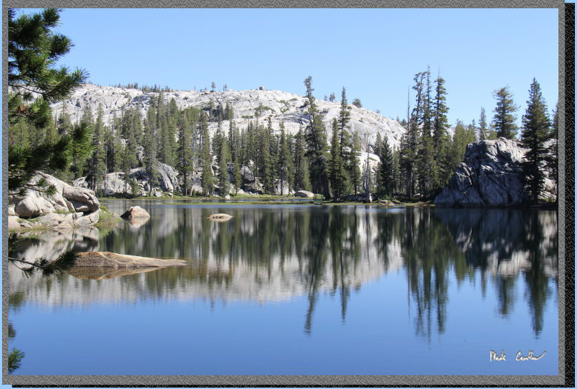
We made it back
to the same campsite at Grouse Lake as night one. Tyler made another
fire that kept what little bugs there were from bothering us. We saw/heard
a few other campers that night at Grouse Lake. This was an awesome trip
with some great sights sprinkled with some good little adventures on
the way. Route finding overall is easy with only a couple sections that
could get tricky if you aren't paying attention (or afraid to check
the map). I am already looking forward to my next adventure with Tyler
out this way. I will leave you with a few shots I took on the way out
on day 5 (the last day).

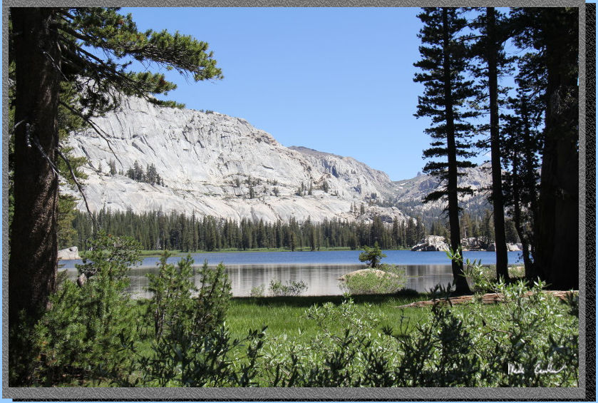
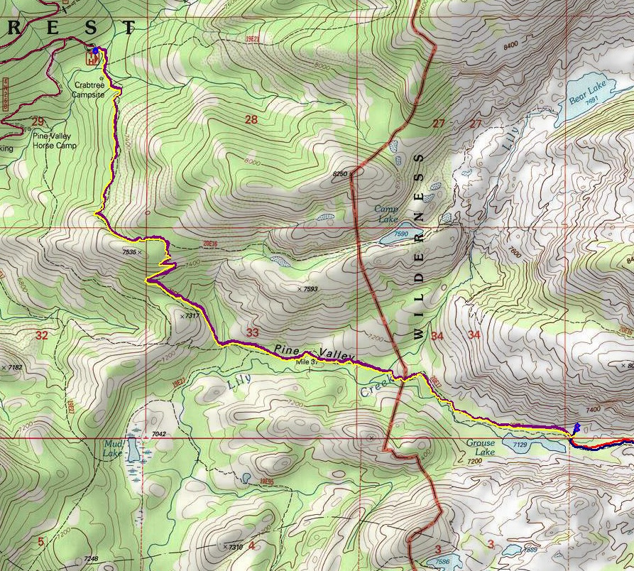
Day 5 (Grouse Lake to Crabtree Trailhead, ~ 5 miles) -Violet Line-

Saying good-bye
to Grouse Lake on the way out.

The stark contrast
of the forest recovering with the backdrop of sad dead trees.

Crossing Lily Creek.

Nice level section
of trail through Pine Valley. This is one of those pictures you see
on trail maps, perfect conditions out there.

The open uphill
section before junction with Camp Lake (most of the uphill section is
covered though).

Looking back out
over Pine Valley. We hiked out on a Saturday and there were many people
headed into the Wilderness that day. I would recommend an early start
or a weekday trip if you want some solitude.

The yellow
line shows Crabtree Trailhead to Grouse Lake (Day
1), the red line shows Grouse
Lake to Wood Lake (Day
2), the green line shows Wood
Lake to Deer Lake (Day
3), the blue line shows Deer
Lake to Grouse Lake (Day
4) and the violet line shows
Grouse Lake to the Trailhead (Day
5). Scroll down for elevation profiles.
Click on map or profiles to be taken to the larger
version.
(Back
to top)
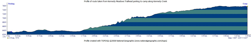
Here
is the profile from the Crabtree Trailhead to camp at Grouse Lake (Day
1).
(Back
to top)
Here
is the profile from Grouse Lake to Wood Lake (Day
2).
(Back
to top)
Here
is the profile from Wood Lake to Deer Lake (Day
3).
(Back
to top)
Here
is the profile from Deer Lake to Grouse Lake (Day
4).
(Back
to top)
Here is the
profile from Grouse Lake to Crabtree Trailhead (Day
5).
(Back
to top)